
NoSky SatNav
Real-time GPS/GNSS for Underground Navigation
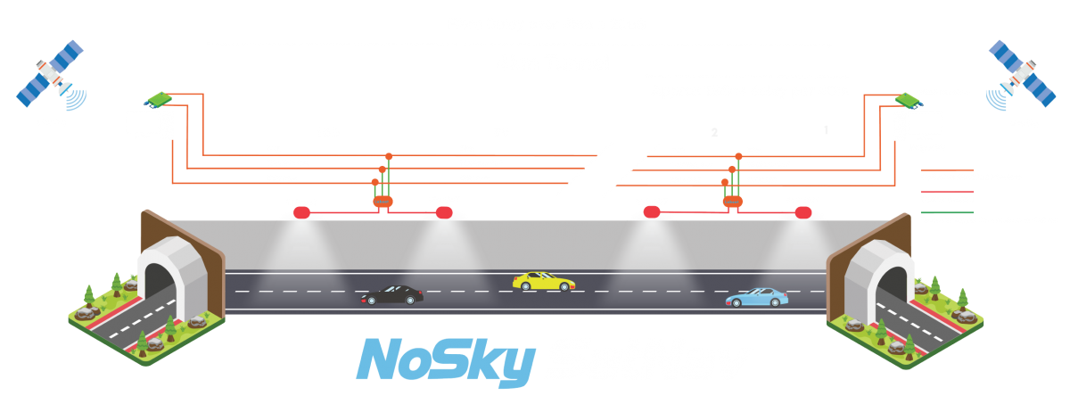
NoSky SatNav is an innovative system that enables GPS/GNSS receivers to calculate latitude, longitude, and altitude within areas that lack satellite signals. This groundbreaking technology emulates signals, allowing GPS/GNSS devices to function seamlessly as if they were under an open sky.
The integration of GPS and GNSS signals in subterranean environments such as tunnels offers significant safety and navigational benefits for all road users, including emergency services. With underground GNSS coverage, navigational services can provide real-time updates on traffic congestion, enabling more informed route planning decisions.
Accurate Time Synchronisation with UTC for Reliable Navigation
External timing references are used to synchronise the NoSky SatNav system to UTC. This allows the system to emulate and radiate the precise data GPS/GNSS receivers would have experienced with a direct view of the satellites.
Improved Emergency Response with Underground GPS Coverage
In emergency situations fast response times are critical. Inaccessible underground areas, particularly those with overlapping sections such as tunnels pose a challenge to effective and timely responses. By providing GPS coverage accident locations can be accurately reported and precisely navigated to by emergency services vehicles.
High Reliability with Fully Redundant Architecture
NoSky SatNav has a fully redundant architecture utilising military-grade hardware with no single point of failure. The system’s extensive monitoring and reporting allows for quick identification and resolution of any issues that may arise. This includes the identification of exact unit faults and comprehensive maintenance guides.
GNSS Signals Provide Compatibility for All GPS-Enabled Devices
Existing systems have used Bluetooth and WiFi beacons to assist with subterranean navigation only compatible with advanced devices such as smartphones. Other GPS-enabled devices such as those often found in transport fleets and some emergency services require true GPS/GNSS signals for accurate positioning.
Spoofing and Jamming Mitigation
Nosky SatNav comes equipped with integrated GNSS spoofing/jamming identification and correction. In the event of a spoofing or jamming attack, the system will disregard the false signals, using alternate frequency, relying on synchronisation with a secondary masterclock or its own extended holdover period.
Contained Radio Frequency Signals
When broadcasting a signal, it is crucial to ensure that the signal does not leak beyond the predefined area. Our advanced tuning capabilities allow for precise control over signal boundaries, ensuring that the emulated signals extend no more than 5 meters beyond the entrance of an enclosed area. This allows for implementation near sensitive infrastructure such as airports and power stations.
Contact Us - NoSky SatNav
To learn more about our NoSky SatNav Solution, please leave your details below and we will be in touch shortly.
Contact Us - NoSky SatNav
To learn more about our NoSky SatNav Solution, please leave your details below and we will be in touch shortly.

NoSky SatNav Real-time GPS/GNSS Location Underground
NoSky SatNav is an innovative system enabling GPS/GNSS receivers to calculate Latitude, Longitude, and Altitude within areas lacking satellite signals. This groundbreaking technology emulates signals, allowing GPS/GNSS devices to function seamlessly as if they were under an open sky.
The integration of GPS and GNSS signals in subterranean environments offers significant safety and navigational benefits for all road users, including emergency services. With underground GNSS coverage, navigational services can provide real-time updates on traffic congestion, enabling more informed route planning decisions.

Real-Time Locked to UTC with Enhanced Emergency Response
External timing references are used to synchronise the NoSky SatNav system to UTC. This allows the system to emulate and radiate the precise data GPS/GNSS receivers would have experienced with a direct view of the satellites.
In emergency situations fast response times are critical. Inaccessible underground areas, particularly those with overlapping sections such as tunnels pose a challenge to effective and timely responses. By providing GPS coverage accident locations can be accurately reported and precisely navigated to by emergency services vehicles.
Contained Radio Frequency Signals with Spoofing and Jamming Mitigation
When broadcasting a signal, it is crucial to ensure that the signal does not leak beyond the predefined area. Our advanced tuning capabilities allow for precise control over signal boundaries, ensuring that the emulated signals extend no more than 5 meters beyond the entrance of an enclosed area. This allows for implementation near sensitive infrastructure such as airports and power stations.
Nosky SatNav comes equipped with integrated GNSS spoofing/jamming identification and correction. In the event of a spoofing or jamming attack, the system will disregard the false signals, using alternate frequency, relying on synchronisation with a secondary masterclock or its own extended holdover period.

GNSS Ensures Device Compatibility
Existing systems have used Bluetooth and WiFi beacons to assist with subterranean navigation only compatible with advanced devices such as smartphones. Other GPS-enabled devices such as those often found in transport fleets and some emergency services require true GPS/GNSS signals for accurate positioning.
Fully Redundant Architecture
NoSky SatNav has a fully redundant architecture utilising military-grade hardware with no single point of failure. The system’s extensive monitoring and reporting allows for quick identification and resolution of any issues that may arise. This includes the identification of exact unit faults and comprehensive maintenance guides.
Contact Us - NoSky SatNav
To learn more about our NoSky SatNav Solution, please leave your details below and we will be in touch shortly.